1: Map of the Lower East Side of New York ca. 1910, Adrian Kitzinger and Ben Singer.
This map shows the locations of nickelodeons, early movie theaters that charged a nickel for admission (allowing you to watch as many short movies as you wanted). These small theaters were popular in the early years of the 20th century.
Suggested activity: Showing the first slide, give a brief explanation of the Lower East Side—a place where millions of Jewish immigrants lived, many in crushing poverty—and ask the students what they imagine the dots on the map represent. Students will often say “synagogues” or something similar.
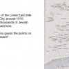
Source: Adrian Kitzinger (cartography) and Ben Singer (research), “Nickeloden theaters on the Lower East Side, c. 1910,” in Entertaining America: Jews, Movies, and Broadcasting, eds. J. Hoberman and Jeffrey Shandler (Princeton: Princeton University Press, 2003), 25.
Movies-01.png
 Download image (802.77 KB)